Copyright and all Rights Reserved Lawrence J. Fleenor, Jr. 1-14-15 Big Stone Gap, Va.
The Federal Government and the individual states have been designating driving tours of many of the old trails in the country. Perhaps the most outstanding example is the Lewis and Clark Trail. Perhaps the next most important effort being made by both the Federal Government and Commonwealth of Virginia is the Wilderness Trail running from Philadelphia to Boonesboro, Kentucky.
The only segment of the Wilderness Trail that is a single trace without alternative routes is the portion that runs from Middlesboro to Pineville, Kentucky. Virginia contains the longest parts of the trail, and it presents itself in numerous variations. The main variant runs the length of the Valley of Virginia to Reedy Creek at Bristol in Tennessee before it reenters Virginia via Moccasin Gap and on to Cumberland Gap. The main alternative to this route runs to the north of the Valley of Virginia along the Virginia – West Virginia border. Its most modern incarnation was the Fincastle to Cumberland Gap Turnpike completed it 1841.
The legislation of 1832 that enabled the surveying of the Fincastle to Cumberland Gap Turnpike is enigmatic, in that it specifies that this survey start at New Castle at “Price’s Turnpike”. References on-line document that there is legislation on record in Virginia authorizing Price’s Turnpike, and that it ended up in the Kanawha Valley of what is now West Virginia. Nothing else seems to be documented in modern literature. This essay’s goal is to do just that.
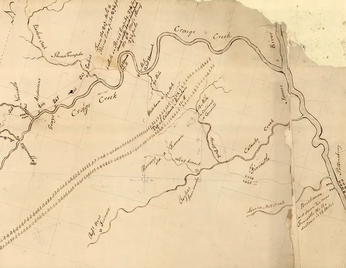
New Castle is an ancient road hub on Craig’s Creek on State 615 in Botetourt, County, Virginia. 615 continues west and is the route of the Fincastle to Cumberland Gap Turnpike as far as US 460 near Pearisburg. In 1833 the Commonwealth of Virginia passed legislation for improvements on this route, which it called ‘The Cumberland Road’. That year it published a map of that route as it ran from Cumberland Gap to the Town of Fincastle, the county seat of Botetourt County, which is just south of the mouth of Craig’s Creek into the James River. This map shows Price’s Turnpike leaving the Cumberland Road in the middle of New Castle, and proceeding north up State 617 following Barber’s Creek. It also documents that this intersection is mile post #6 of Price’s Turnpike. It is six miles to the mouth of Craig’s Creek.
The New River starts near Boone, North Carolina, and flows north through Virginia by Radford and passes into West Virginia at Narrows. Its first major tributary in West Virginia is the Greenbrier River, which comes in from the East. Its major city is Lewisburg. This town is situated on an ancient Indian Trail intersection of the Seneca Trail that ran from Buffalo, New York to the Narrows. The other trail is the Midland Trail that ran from Charlestown, West Virginia to Hampton Roads, Virginia. It is important to note that the New River changes names in its course through West Virginia, and becomes the Great Kanawha River.
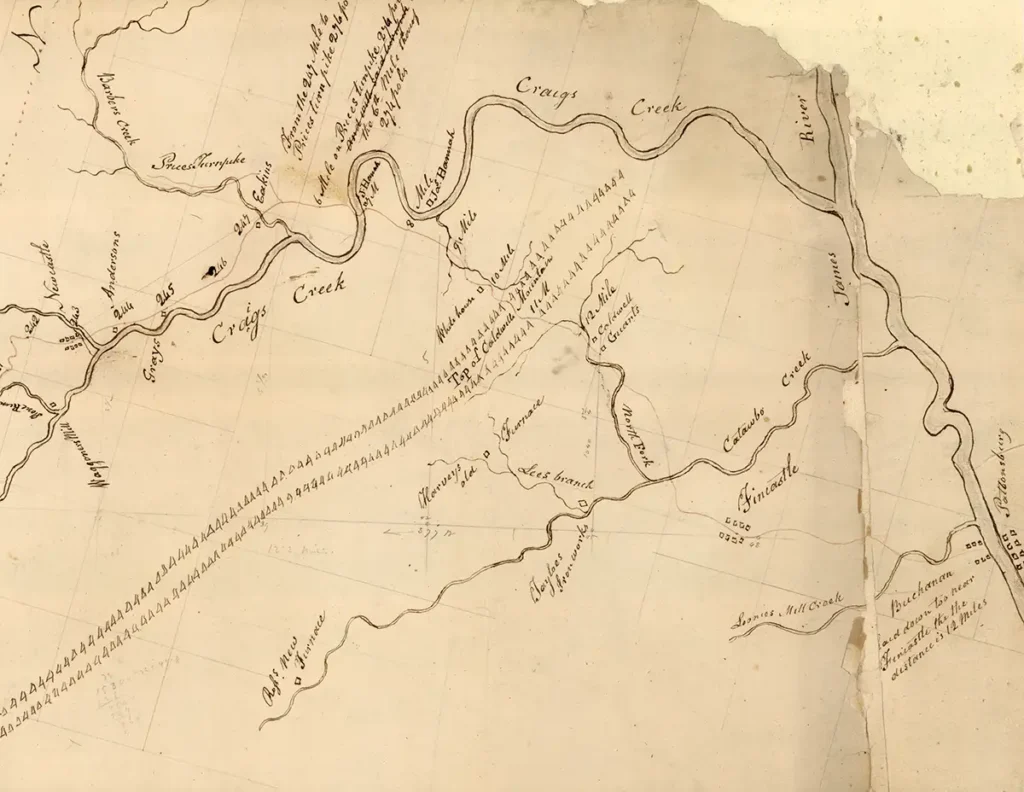
A PORTION OF THE 1833 MAP OF THE ‘CUMBERLAND ROAD’ SHOWING THE ROADS AROUND NEW CASTLE
It is said that the Midland Trail more of less follows US 60. It is doubtlessly true, but it seems that its route across the Alleghenies from the Valley of Virginia to the Greenbrier Valley went to the south of present US 60 and its modern version – I-64. Price’s Turnpike was most likely the route of the Midland Trail across the Allegheny Mountain.
Oral tradition, widely held, in Botetourt County is that the ‘old road from Lexington’ came in a direct line following State 612, which is named ‘the Blue Grass Trail’ today. This same name is applied to State Highways of various numbers to a route that lies all the way to the Valley of the North Fork of the Holston River in Washington County. This route represents yet another variant of the Wilderness Trail, and which lay between the Fincastle to Cumberland Gap Turnpike and the main trail down I-81 in the Valley of Virginia.
The route turns to the west to the right off of 612 onto State 622, the Mill Creek Road. Both these routes are today obscure gravel roads, but 300 years ago they passed significant iron works, such as Jane and Rebecca Furnaces, which still stand today. Rebecca Furnace still has its iron master’s house standing. Mill Creek overlays a deep crack, or fissure, in the earth’s crust. Warm mineral water flows up this fissure for the entire length of Mill Creek. In the early 19th Century there were spas at Dagger’s Spring and at Gala at the intersection of 622 and US 220. The ancient route follows the combined State 622 and US 220 for about a mile, and turns off on Price’s Bluff Road, which carries the number of State 622 beside the James River to Price’s Bluff. The old trail fords the river near this point.
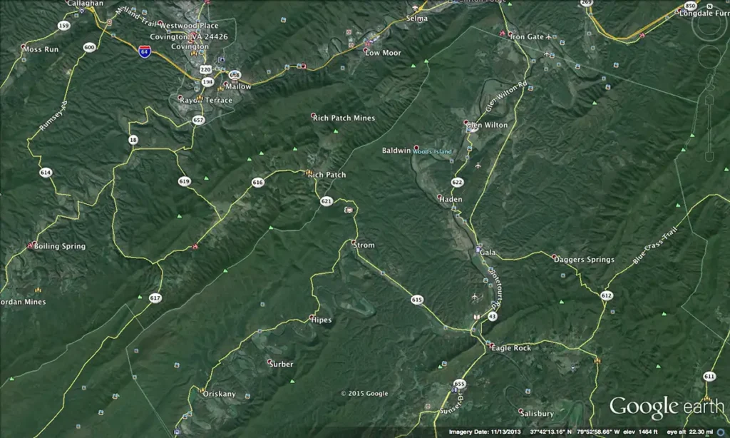
A MODERN MAP COVERING THE ROUTE OF THE MIDLAND TRAIL AND OF PRICE’S TURNPIKE AS THEY BYPASS I-64
The first name of the Price who lived at Price’s Bluff and at the start of Price’s Turnpike is unknown. Review of the existing records, including land patents, shows a strong concentration of Prices in this area. One would suspect one of the numerous William Prices or the son Samuel. Descendants migrated both into the Greenbrier Valley and down the Fincastle to Cumberland Gap Turnpike. No one knows if the namesake of Price’s Turnpike and of Price’s Bluff are one and the same.
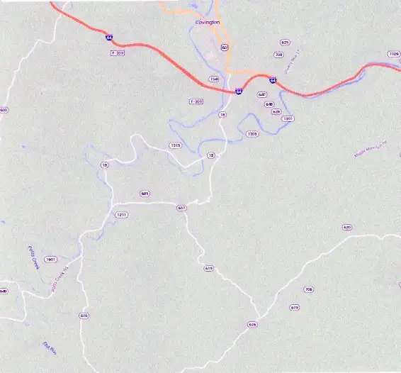
At any event, Price’s Turnpike started at the mouth of Craig’s Creek, and followed current State 615 to New Castle. There is turned northwest up Barber’s Creek on State 617. It went around the western end of Rich Patch Mountain to State 616, and then down the north side of the Allegheny on State 18 to rejoin US 60 and I- 64 at Covington. We do not know its western terminus, but it likely was modern White Sulfur Springs (the old name was Blue Sulfur Springs), where it joined the Lewisburg to Blue Sulfur Springs Turnpike.
MODERN ROAD MAP OF THE ROUTE OF PRICE’S TURNPIKE BETWEEN NEW CASTLE AND COVINGTON
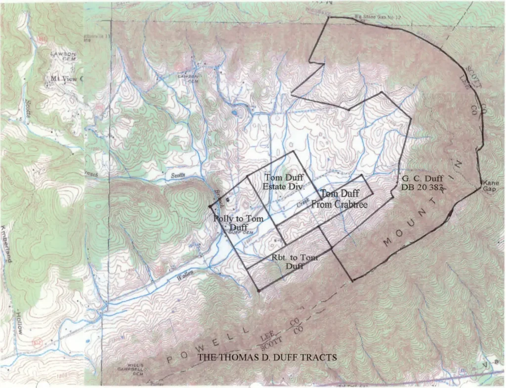
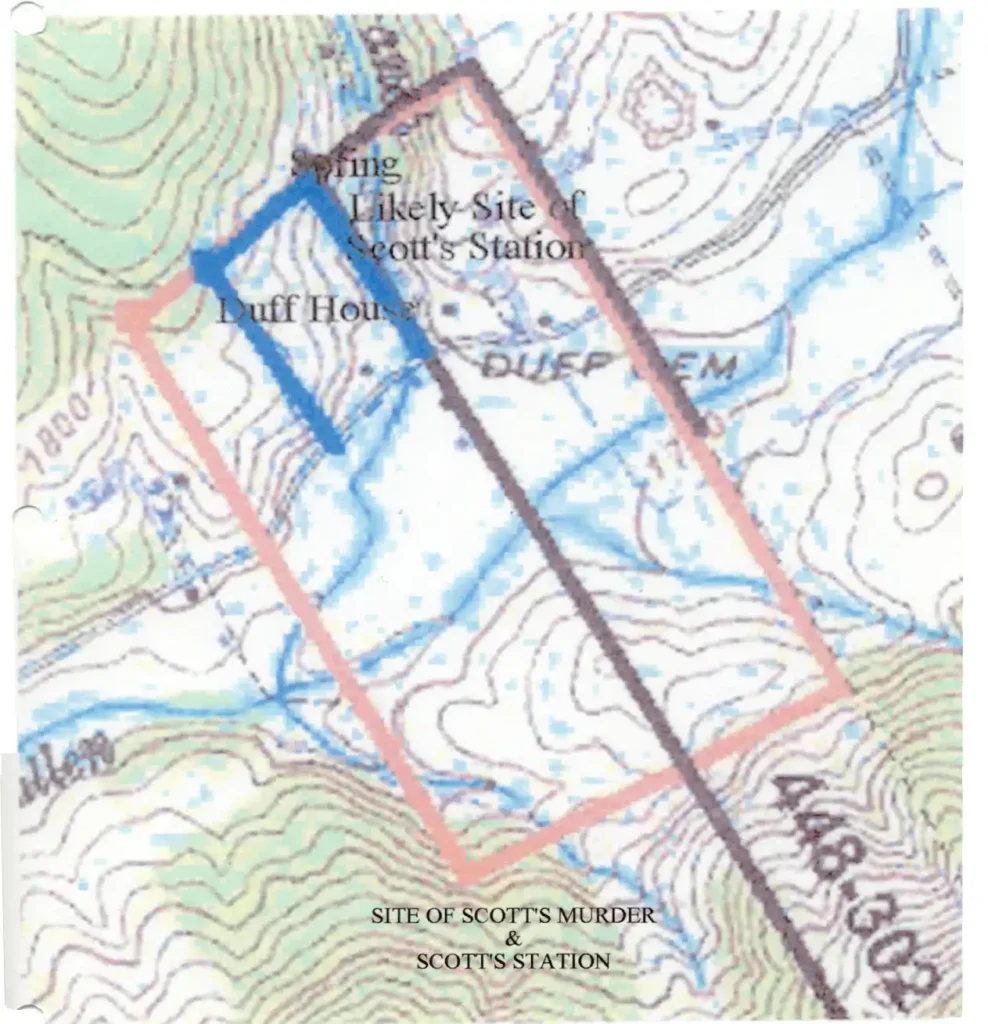
TO DEFINE ON A TOPOGRAPHIC MAP THE LOCATIONS OF THE HOME OF ARCHIBALD AND FANNIE SCOTT SCOTT’S STATION THE LOCATIONS OF THE DANIEL BOONE WILDERNESS TRAIL WITHIN THE BASIN FORMED BY THE HEAD OF WALLEN’S CREEK
By: Lawrence J. Fleenor, Jr. Dale Carter Copyright Lawrence J. Fleenor, Jr. Big Stone Gap, Va. Dec. 2001 Retranscribed in ‘Word’ 7-8-15
Background
A significant amount of history has occurred within the semicircle of Powell’s Mountain where it forms the head of Wallen’s Creek in eastern Lee County, Virginia. The Great Warrior’s Path, later known as the Boone Trail or the Wilderness Road, passed through here. The militia party conduction the infamous Governor of Upper Canada, Henry ‘Hair Buyer’ Hamilton, into captivity spent the nighnt of April 28th, 1779 camping at “Scott’s Improvement” (1). The famous massacre by Chief Bob Benge of its first settler, Archibald Scott and his children, and the carrying off into captivity of his wife, Fannie Scott, occurred here in 1785. In 1793 the famous confrontation between Ensign Moses Cockrell and the same Chief Benge occurred here. The Holston Militia of The State of Virginia maintained a blockhouse garrison named after Scott here during this period. Scott’ home, and the later Scott’s Station are often blended in people’s minds into one, but were, in fact, different structures said to have been located ”near” the same site.
Further complicating the conceptualization of this basin as it existed in the last decde of the Eighteenth Century is the confusing evidences concerning the location of the above mentioned trail / road after it left Kane Gap atop {Powell Mountain on its way trough the basin at the head of Wallen’s Creek. The trail started off as a buffalo path, and ended up as a vehicular road. Not surprisingly, the topographic requirements of each are different, leading to different locations of what in reality were two different routes.
Methodology
The basic framework of the research is one of land grant analysis joined with the analysis of later deeds covering the same land, using the associated data from their surveys to locate the historic sites on a modern topographic map. Other data, such as from historic narratives, will be used to flesh out the survey data. The process will be spelled out step by step, and the underlying documents will be supplied, both to serve as a complete historic resource for future use, and to allow the reader to follow the process step by step. Scans of the resulting topographic maps, and a bibliography of sources will be attacked.
The Early Land Grants
Archibald and Fannie Scott had married at Castlewood, Russell County, Virginia. She was the sister of Humphrey Dickenson, who settled in Castlewood in 1769 (2). The 28th and 29th of October 1783 Scott had a 400 acre, a 336 acre, and a 396 acre tract surveyed. They had sometime earlier fulfilled the legal requirements of having “settled” on the land, which were that they had lived there long enough to have planted an acre of corn for each ten acres granted. The planting need not have been much more than ceremonial, and they did not have to continue to have “lived” here to have gained the right to a land grant for the nearly 1000 acres of land. The 400 acre tract was officially designated as the “settlement right”, but this does not necessarily imply that this is where they settled after they had been granted the land, as they were June 20,1785.
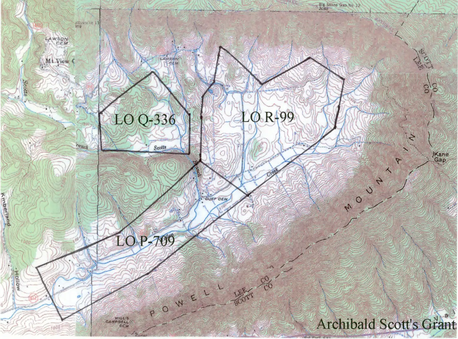
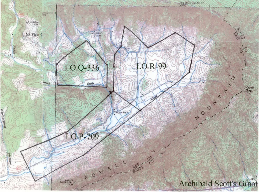
These land grants are available on the internet form the Library of the State of Virginia, and they and all other related grants will be designated by the system used by that source (3). The reference numbers for the three Scott grants are R-99, P-709, and Q-336. June 29, 17895 Archibald Scott and all his children were murdered by Chief Benge’s war party at their home on this land, and Fannie was carried off into captivity (4). She escaped and returned to the settlements August 11th, but may have been declared dead, as the land at the head of Wallen’s Creek passed to Archibald’s brother, James, who was listed as Archibald’s “heir-in-law. In July 1790 he sold these tracts to Thomas Johnson who became Fannie Scott’s second husband is unknown, as this Thomas Johnson for 220 Pounds (what relationship he may or may not have had to the Thomas Johnson who became Fannie Scott’s second husband is unknown, as this Thomas Johnson’s wife is listed as “Susannah” on the deeds (5). Thomas Johnson sold this land to Robert Duff (date unknown) (6). The texts of the land grants adjoining this property that list it as being Duff’s “settlement right” are an error.
Robert Duff, who had been born in Ireland 6-23-1755, and his wife Mary “Polly” Dickenson, settled on this land, and had ten children. Polly was Fannie Scott’s niece. After his death 6-20-1820 his estate, which consisted of the 978 acres of Archibald Scott’s land that he had bought, plus an additional 150 acres he had been granted from the State (Land Office 65-237), was divided among his ten children, with his son Thomas D. Duff getting a one tenth share, or 110 acres (7). Coale’s Wilburn Waters page 201 states, “Archibald Scott’s cabin was near the book was written in 1878, less that a hundred years after the Scott massacre, the information would seem to have reasonable likelihood of being accurate. With this being the case, the problem of identifying the site of the Scott slaying becomes one of locating on the topographic map the land of Thomas D. Duff. This process begins with locating the three land grants of Archibald Scott on the topographic map. As all the descriptions of the metes and bounds of these three tracts are notated in terms of trees that have long since gone, the process becomes one of charting the adjoining land grants to those of Scott in an attempt to construct a ‘grand block’ of contiguous grants which would stand a greater chance of being situated on a modern map. Grants 65-237, 79-431, Q-336, 82-20, 112-490, and 81-330 are adjoined to the grants of Scott’s, but still not enough information exists to plot this block of grants on a modern map.
The Steel Tracts
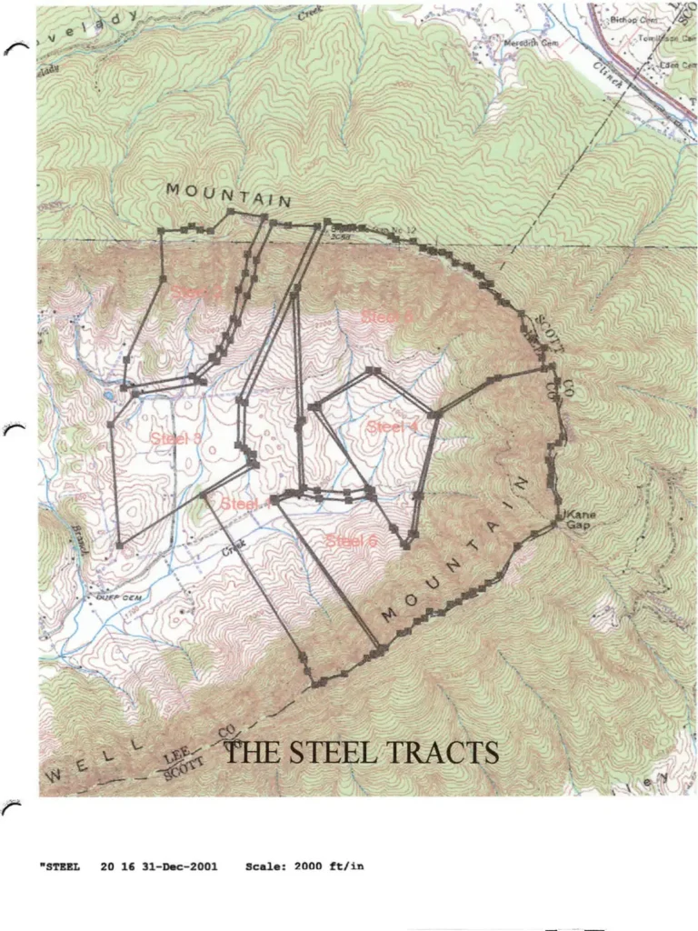
About 1911 Fred R. Steel began to buy up the basin at the head of Wallen’s Creek. In 1934 he mortgaged the land, and a modern survey (9) was done, and one of the corners of this survey mentions the fact that it is a corner of the old Archibald Scott grant. Due to this property’s outer metes and bounds being the ridge crest of Powell Mountain, and due to the fact that this crest makes a horseshoe around the head of Wallen’s Creek, it is easily accurately postioned on a modern topographic map, thus locating a specific corner of the Archibald Scott block of grants in the process. (Steel Tract #1 point ‘A’ is the old Scott corner, or LO R-99 point ‘F’).
As the Steel land did not include the land formerly owned by Thomas D. Duff, the title analysis for the Steel land does not include a description of the Thomas d. Duff land. However, retrogressive deed analysis from the Steel title abstract shows earlier surveys of tracts that conveyed land from the Duffs to Steel (10), and which contain three survey references to the land of Thomas D. Duff. By this means the land of Thomas D. Duff can be topographically related to that of Archibald Scott.
The Jan. 18, 1884 deed from G. C. Duff to William P. Duff is accurately plotted on a topographic map not only because, it too contains the mountain crest rim of the horseshoe of Powell Mountain, but it contains a point at Kane Gap, a known entity. Point ’W’ of this survey is a common corner with one of Thomas D. Duff’s. It also shares common metes and bounds with the March 16, 1841 William Carnes to Thomas P. Carnes tract, which contains a point and a line with Thomas D. Duff. Using these geographic points of reference, one can approximately localize the tracts of Thomas D. Duff.
The Tracts of Thomas D. Duff
The records in the Lee County Court House at Jonesville contain the deeds of four tracts of land owned by Thomas D. Duff, and they are as follows:
A) John Crabtree to Thomas Duff et al, fifty acres, Oct 15 1839 DB #8 pg. 202 B) Polly Duff to Thomas D. Duff, 110 acres, March 23, 1840 DB #15 pg. 38-39 C) Robert Duff to Thomas Duff, 50 acres, Feb. 18 1841 DB #8 pg. 354 D) Polly Duff to Thomas Duff, 110 acres, Jan. 29, 1842 DB #8 pg. 452 The first tract contains a common corner and a line with Archibald Scott’s land, while the second is from the estate division of his parents, William P. and Elizabeth (Polly) Duff. The Scott and the Steel title abstract corners help locate the tracts of Thomas D. Duff on the topographic map.
The modern farm owned by Lawrence Tankersley contains the traditional site of Scott’s death and of the later station (11). Its location comes very close to the calculated location of the 110 acre tract sold to Thomas Duff by Polly for $100 and “love and affection”. It would seem likely that this tract was the site of the home of William and Polly Duff, and the widow in her old age was turning the homeplace over to tom, possibly in exchange for his caring for her. The metes and bounds of the Tankersley survey contains references to the “corner to the Polly Duff line” and to “Thomas D. Duff’s line”. Correlating these metes and bounds from the old and the modern surveys proves that the northern part of the current Tankersley farm is cut out of the northern part of the 110 acre Polly to Tom Duff tract, plus some of the land from the Duff tract to its west. This proves that the traditional general sites of Scott’s home and Station are correct.
There are other substantiating evidences to support this conclusion. The topographic map (12) identifies the creek coming from the northwest and joining Wallen’s reek at the Duff Cemetery located north of LO P-709, as being “Scott’s Branch”. The current road map of Lee County that is painted on the wall of the Clerk’s Office in the Jonesville Court House labels the intersection of Scott’s Branch and highway #612 as being “Scott’s”. The Duff Cemetery located on this tract is said to have been started by the graves of Scott and his children.
Until very recently, springs were critical in the location of people’s homes. Even more importantly, it was an invariable requirement that a good reliable spring be located within easy rifle shot from every frontier fortification. This was to insure that an individual going out of the fort for water could be covered by rifle fire from within the fortification. As a practical effect, every frontier fortification in the region was located no more than about 75-100 yards from a good spring. The spring located to the northwest of the current log Duff house (presumed to have been the home of Thomas D. Duff) and on the eastern bank of Scott’s Branch, is now dried up, but was the source of water to this house, as well as to the houses cross the road to the south, and to the Powell Academy School which was located across Scott’s Branch to the west, well into the last half of the Twentieth Century. (13)
This is as far as present information will take us. Only an archeological examination of this site is likely to produce greater documentation.
The Location of the Daniel Boone Wilderness Road From Kane Gap to Scott’s Cabin
The evolution of the Trail or Road is, in general, well known. It started of as a buffalo trail, passed through a prolonged phase as a human foot trail, and for a brief period as a vehicular road.
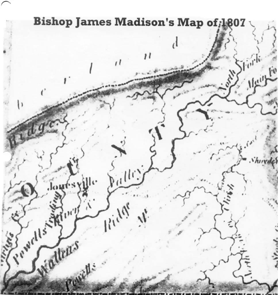
The first improvements were made by Daniel Boone in 1775 when he and his party of axmen improved the old Indian Trail all the way to Boonesboro, Ky. It is known that the only earth moving that they did was on the “Dug Road” segment on Pine Mountain’s eastern face at Moccasin Gap. Soon, however, the trail was improved to the point that it would accommodate darts as far as Martin’s Upper Station at Rose Hill, Virginia. Bishop James Madison’s official map of the State of Virginia of 1807 (14) (see Madison’s Map file) shows that the Kane Gap route had been abandoned in favor of the current passage of US 58 and 421 through Eller’s Gap near Pattonsville.
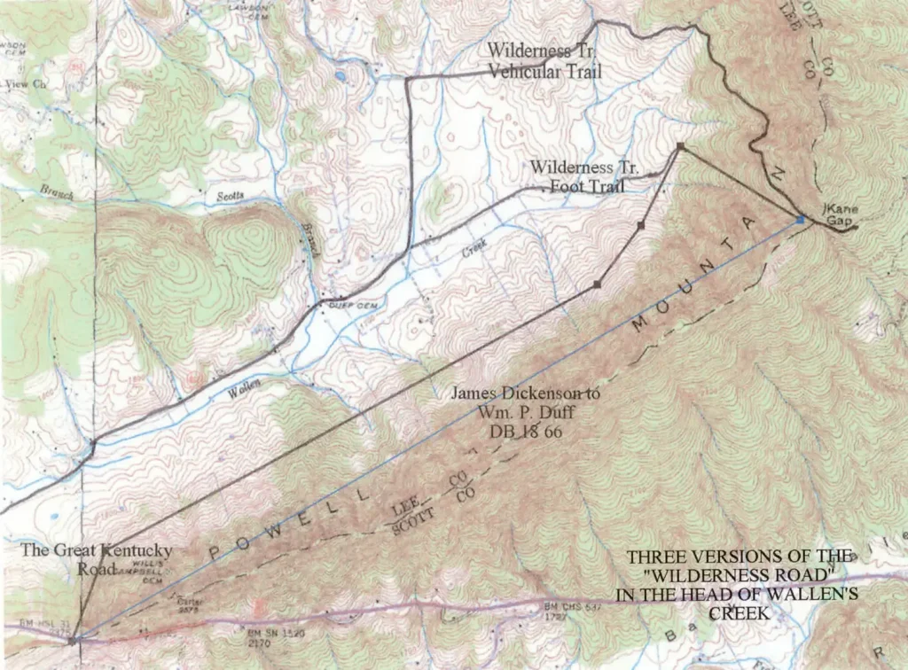
There is ample evidence of two routes for the Great Warrior’s Path – Wilderness Road – Boone Trail from Kane Gap to Archibald Scott’s. Coal’s Wilburne Waters pg. 153-154 says that Ensign Moses Cockerell ran two miles from Kane Gap to Scott’s Station to escape Chief Benge. Pusey gives that distance as recorded in a pioneer’s journal as having been three miles (15). Well into the Twentieth Century mail was carried from the depot at Duffield across Kane Gap by horseback. The trail used by the mailman on horseback came down the western bank of the head of Wallen’s Creek which states right at Kane Gap, and came straight on down the slope of the mountain to the road designated on the topographic map as running east from Thomas D. Duff’s home parallel to Wallen’s Creek to the foot of the mountain. Wagons were unable to use this bridal path due to its grade (16). The wagon road leaving the northern lip of Kane Gap takes the eastern bank of the head of Wallen’s Creek and uses the curving slope of Powell Mountain to make a near 180 degree turn as it slowly descends to the basin at the head of Wallen’s Creek Valley, and to rejoin the foot trail at Thomas D. Duff’s estate division.
Inspecting the roads from Kane Gap, itself, one can see lots of evidences of the foot trail, and vehicular trail is still very much in use by horses and all terrain vehicles, and is marked on the topographic map.
Buffalo spilling over the Gap to the north would have paid no attention to grade, and would have taken the shortest route to the valley floor, just as the deer trail of today does. The trail to the left (west) of the head of Wallen’s Creek and Kane Gap is easy to see and to follow for its first couple of hundred yards. There are no signs of excavation. However, one can see trough like depressions created by a mix of centuries of foot traffic and by erosion. Going through a hillside of stones, one notes that there are none down one of these linear depressions for the ground on both sides is littered with them, and notes further that the deer make current heavy use of this line of travel, just as surely did the buffalo and the Indian and pioneer foot travellers that followed them. The trail gets lost as the mountain gets steeper, and it can no longer be followed to the valley floor. The grade is close to the maximum practical limits that a horse and rider can negotiate, and exceeds what an be accomplished by a horse drawn vehicle.
The mileages noted above are significant. It is two miles from Kane Gap to the traditional site of Scott’s Station by the foot trail, and three if one were to take the vehicular road. This observation explains and ratifies the two distances noted in the historic documents above.
The survey contained within the deed of the tract of land sold by James J. Dickenson to William P. Duff on May 21, 1877 defines a leg of that tract running N62W from Kane Gap with “an old road” (17). This is the bearing of the foot trail as it leaves Kane Gap to the north along the left hand bank of the head of Wallen’s Creek.
Incidently, the western leg of this survey is along “the old wagon road” which was called earlier the Great Kentucky Road and later the Fincastle Turnpike, and demonstrated that the road then took a northeastern rather than a northwestern course out of Eller’s Gap. This routing replaced the foot trail and the vehicular road through Kane Gap before 1807.
In summary, there are ample evidences of both the earlier foot trail, and the later vehicular trail running from Kane Gap to the floor of Wallen’s Creek Valley.
Bibliography: 1) The Bear Grass, a History – by Lawrence J. Fleenor, Jr. pgs. 56-59 2) “The Killing of Humphrey Dickenson” by Emory Hamilton 3) http:image.vtls. com/collections/LO.html 4) Benge! – by Lawrence J. Fleenor, Jr. 5) Russell County, Virginia Deed Books 1-131, 1-126, 1-129 6) Russell County, Virginia Deed Books 1-168, 1-69 7) Title Abstract entitled “Duff / Steel Property” made by the law firm Irvine & Morison Feb. 1911, owned by Eunice and Mary Ruth Laster 8) Published originally in the 19th century by the editor of an Abingdon newspaper, and republished separately, or as part of Summers’ Annals of Southwest Virginia vol. II by the Overmountain Press 9) Lee County Deed Book 87 pg. 463; a cp[u os om a compilation of related material entitled “Duff / Steel Property” owned by Eunice and Mary Ruth Laster 10) Pgs. 39 and 48 of #6 – G. C. Duff & Mary E. Duff to William P Duff Jan 18, 1884; survey descriptions of tracts 7 & 8 of a law suit between John W. Carnes V. Eliza A. Carnes (Lee County 1866) 11) Lee Co. Deed Book 421 pg. 771 12) US Dept. of Interior Geologic Survey 7.5 Map, Duffield Quadrangle 13) Mrs. Lawrence Tankersley, owner of this tract today; and Mr. Jim Young, who lives in the house south of the road, and who used to get his water from the spring until it went dry 14) Located in the Rare Book Room of Alderman Library at the University of Virginia 15) Pusey, The Wilderness Road to Kentucky – pgs. 26-114 16) Communication to the author by Mr. Eunice Laster, who has spent his life in the head of Wallen’s Creek 17) ibid #6 above, pg. 38 – Lee Co Deed Book 18, pg 66
Postscript
As if there were not enough pathos already associated with Scott’s Station, while looking over the Duff Family Cemetery at the site of Scott’s Station, I became immersed in the tragedies of the next generation of Duffs. Three of Robert P. Duff’s grandsons died in the Civil War. In the center of the grave yard is a single shaft engraved on four sides. It looks at first like a tomb stone, but it is rather a memorial to family members buried elsewhere. On the one side is a memorial to Robert Duff, Jr., who had moved east to Staunton, Virginia. The monument records that he died and was buried in Staunton in 1888. On a second side of the shaft is an inscription to his son William Washington Duff, “born April 12, 1844 and who died June 5, 1864: buried at Point Lookout, Md.” The stone says no more.
Point Lookout was opened by the Union Army after the Battle of Gettysburg and became on the largest of the Confederate Prisoner of War camps. It came to imprison over 52,000 Southern soldiers and southern sympathizers, of whom over 14,000 died. The camp was built at the tip of the peninsular formed by the junction of the Potomac River and the Chesapeake Bay. The land was marshy and the conditions were over crowded. The Confederate prisoners were made to suffer for the conditions t the confederate POW camp at Andersonville. The prisoners at Point Lookout were purposefully deprived of rations, causing them to eat rats. Diarrhea, malaria, scurvy, tuberculosis, and exposure killed prisoners at a rate at a rate as great as many of the bloody battles. The Union officials were in a state of denial over this, as they were in process of executing the commandant of Andersonville for having presided over much the same obscenity, and the government only admitted to 3,384 deaths at Point Lookout. Among those modern records list as being among the unadmitted victims buried at the prison cemetery at Point Lookout is listed “Duff, W. W., CO H 5th Va., P/W Died while P/W At Pt. Lookout, Md.”
“The Bloody Fifth” Virginia Volunteer Infantry Regiment was organized April 13, 1861 in Augusta County, of which Staunton is the largest town. Company ‘H’ was called the “Augusta Rifles”. The Fifth became part of the Stonewall Brigade, and no unite saw heavier combat. Few survived the war. We do not know when W. W. Duff was captured, but in less than a year after the Battle of Gettysburg, in which the Stonewall Brigade played a prominent role, William Washington Duff was dead at Point Lookout.
Another side of the stone shaft in the Duff Cemetery at Scott’s Station memorializes another of Robert Duff, Jr.’s sons, Thomas Jefferson Duff. He was “born 7-31-1842 and died May 5, 1864; CSA: Killed in the Battle of the Wilderness – God defends the right.” We do not know his unit, but it is possible that he also had joined the Fifth Virginia along with his brother William Washington. The Stonewall Brigade played a prominent part in the Battle of the Wilderness.
Nearby is the monument to “Our Soldier Boy”, Robert Duff III, who it notes was born in 1844, the same year as his cousin William Washington, and who was “killed at Chancellorsville 5-2-1863: CO G 50th Reg., Va. Volunteer Line.” Toward the end of the War, the remnants of the Stonewall Brigade were combined with what was left of other units, the 50th among them.
So, here in this seemingly most isolated and peaceful valley lie recorded events of tragic violence unimagined by the passer by of today. Archibald Scott killed in his bed, his daughter’s brains dashed out as she was being held in her mother’s arms; and to the grandsons of this first generation we see memorials of their deaths in distant places, buried far from home, and mourned in absentia by those who remained.
No river crossing on the entire Wilderness Trail had such historic significance as the New River Crossing at present Radford. The fort that guarded it, though of significant use during three wars, is little known. This original article explores that river crossing, and the fort that guarded it.
The New River cuts south to north through the Alleghanys, and thus provides passageway through the mountains of the east where the rivers otherwise flow generally either east or west. It furthermore transects the Great Valley of Virginia, and naturally forms a hub of Indian trails that connect the Seneca of the Buffalo, New York area, the Shawnee of Ohio, the Delaware of Pennsylvania, and the Cherokee of the Smokeys. It was, therefore, natural that when the Indians of the Ohio Valley began to resist the pressure of English settlement into the Mississippi watershed, that the intersection of the Great Warrior’s Path (the Wilderness Trail) and the New River at present Radford, Virginia should become the hub of frontier warfare.
This situation is accentuated by the existence of the Little River (in earlier times called the Middle River), which provides a natural corridor connecting the lower Roanoke River Valley of Southside Virginia with the New River. By 1654 the English settlement around the mouth of the James River had stabilized and expanded to the point that there was an official legally designated trading center set up at present Petersburg for commerce with the Indians in the Yadkin Valley of North Carolina, and beyond. It was that year that Col. Abraham Woods sat a coarse west from Petersburg to seek out new opportunities of commerce to the west. Coming to the west from present Floyd County he crossed the Blue Ridge at Wood’s Gap, and thus passed to the head of the Little River. Following this river to its mouth into the New River at Radford, he became the first European to see that river. He named it Wood’s River, a name that the upper reaches of that river carried for many years.
According to Major Jed Hotchiss of Staunton, Virginia, a man named “New” maintained a ferry on the Wilderness Trail near Radford in the days before the Ingles family became involved in that business. The upper reaches of Wood’s River became known as the New River, while its lower end which was accessed from the Ohio River was called the Kanawha.
In 1749 German Moravians, Sabbatarians, and Brethren from Pennsylvania were settling Dunkard’s Bottom (Radford, Virginia) on the New River, and found there a “kind of white people who wore deer skins, lived by hunting, associated with the Indians and acted like savages.”
Early references note the “Cherokee” village at Dunkard’s Bottom. The ‘Dunkers – Dunkards’ were a variety of German Brethren, who practiced baptism by total immersion. The settlement at Dunkard’s Bottom had close ties with Brethren communities in Pennsylvania and in the Winston-Salem area of North Carolina. The word ‘dunken’ is the old German form of the modern German ‘tunken’, which has come into American English as ‘dunk’. The Brethren called their settlement on the New River at Radford ‘Machaniam’, which is a place name taken from the Book of Genesis. The ‘Cherokee Village’ and the Dunkard’s Bottom community of Machaniam seem to have become one and the same place.
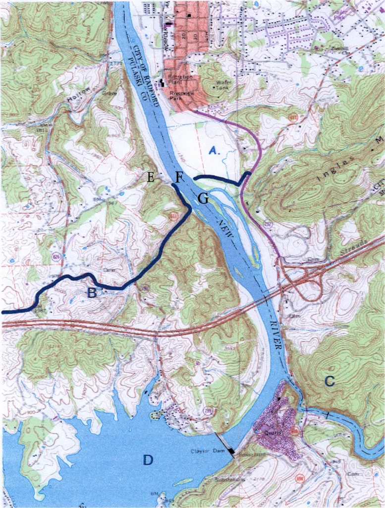
Dunkard’s Bottom is usually said to have been covered by the lower reaches of Claytor Lake, whose dam is just upstream (south) on the mouth of Little River. The land patent of 1753 to Garratt Zin (also spelled Garrett Zinn) LO 32-148 covered 900 acres on the west bank of the New River opposite the mouth of the Little River, and extended north to include what was to become the western side of the Ingles Ferry / Bridge operation. The patent for this land specified that the place was called ‘Machaniam’, thus proving that the community of Brethren extended further north along the New River than is generally accepted. Title to this land was clouded by the Royal Proclamation, which was the implementation of the treaty that ended the French and Indian War in 1763, and which annulled all the land patents west of New River. Exactly how it passed to the Ingles Family is unknown.
In the 1740’s and early 1750’s King George II had set up large land companies, such as the Ohio Company and the Loyal Company, to encourage settlement in the Mississippi Valley. This was English policy to counter the French claims to the area. The settlements included Reedy Creek to Kingsport, the Valley of Virginia, the Valley of the Greenbriar, and the New / Kanawha River settlements. In July 1755 the main British army under General Braddock was wiped out near Pittsburgh by the French and Indians. This disaster opened up the Virginia frontier to raids by the Shawnee Indians of Ohio, who felt that the New River Valley was theirs. Later that year numerous settlers were killed, and the old trader Samuel Stahlnacker of Chilhowie, and Mary Draper Ingles were kidnapped and taken to the Ohio villages. Mary had been living at Draper’s Meadows, or present Blackburg, and was involved in the Draper’s Meadows Massacre. Her mother had been killed. Upon making her escape, Mary was taken to the “fort at Dunkard’s Bottom, on the west side of New River, near Ingles Ferry.” It is very improbable that there were two forts so close together. It is very likely that the “fort at Dunkard’s Bottom” and “Fort Frederick” were one and the same.
A – Ingles House B – Wilderness Road C – Mouth of Little River D – Claytor Lake & Dunkard’s Bottom E – Ingles Inn & Tavern F – Ingles Ferry G – ford
In Feb. 1756 the Augusta County Militia mounted “The Shawnee” campaign to pacify the Shawnee Indians who were running amok in western Virginia. It is not known when it was built, but likely it was in response to the Draper Meadows Massacre. Fort Frederick was built “opposite the mouth of the Little River”. Otis Rice quoting the Draper Manuscripts further states that Fort Frederick was “near Ingles Ferry, and “was up river from Ingles Ferry at Little River”. This is all that is known of its location, but it is a reasonable supposition that it lay on the Wilderness Road, and guarded the western approaches to the ford which was just to the north of the mouth of the Little River. It is not known for whom it was named, but Capt. Archibald Alexander of Rockbridge County is a likely candidate, as he was a part of the militia party from Fort Alexander that became known as the Sandy River Expedition.
Overall command of the expedition was under Major Andrew Lewis of Salem, Virginia. Capt. William Preston and Capt. Archibald Alexander were part of its officer corp. The expedition consisted of about two hundred militiamen, and one hundred Cherokee (actual total said to have been 340). William Ingles, husband of Mary, was in the party. They took 27 packhorses. The plan was to avoid the customary routes in order to avoid detection. They left Fort Frederick the 18th or the 19th, and cut across Burke’s Garden and into Abb’s Valley. They reached the headwaters of the Big Sandy River Feb. 28th. The rivers were flooding, and on March 12th Major Lewis’s canoe, and also another, sank with many of their provisions lost. Game was more scarce than they had imagined. Their provisions were cut in half. They refused the order to kill and eat their horses, and on March 13th there was something of a mutiny, as the men refused to go further. They had gotten as far as the general vicinity of Logan, West Virginia. They boiled and ate the rawhide laces that held their harnesses together. These strips of rawhide were called ‘tugs’, and thus the place where they ate their tugs became known forever more the ‘Tug Fork of the Big Sandy’.
The party broke up into small units, and on the way home many froze to death, and many were killed by Indians. They returned to Fort Frederick. The House of Burgesses held a formal hearing, but cleared Lewis of any wrongdoing.
The Royal Proclamation of 1763 placated the Shawnee for a while, but when the settlers began to creep back into the country west of the New River, the Shawnee again made a bid to clean out the New River Valley. The result was Lord Dunmore’s War of 1774, and its single battle, the Battle of Point Pleasant.
Indeed, part of that resettlement of the western bank of the New River was made by the Ingles family, who in 1762 opened up a ferry on the Wilderness Road, which is still named as such, and whose State # is 611.
In 1774 the Shawnee made no secret of their plan to invade Virginia and to enforce the terms of the Royal Proclamation. Once again the Western Virginia Militia under Andrew Lewis and William Christian congregated at Fort Frederick (“the New River Ford, later known as Ingles Ferry”). Lord Dunmore and the Eastern Virginia Militia marched to the fort at the forks of the Ohio at Pittsburgh. It was the old French Fort Duquesne, which Dunmore renamed after himself. It later became known as Fort Pitt.
In recent years, Claytor Lake was drained in order to effect repairs to the dam. During this event a modern archeological evaluation of the community of Dunkard’s Bottom, including the home of William Christian, was made. No remains of a fort were found under Claytor Lake.
Sept. 12, 1774 Andrew Lewis and his militia left Fort Frederick for Lewisburg, W. Va. (Camp Union), where the general muster was to take place. The force mustering at Fort Frederick included companies from East Tennessee, Clinch Valley, Powell Valley, and Holston Valley. No exact count of the number of men involved was kept, but a reasonable estimate would be 300-400. This is the last mention of Fort Frederick in the available historic documents.
In July 1776 William Christian, who was married to Patrick Henry’s sister, led the New River Militia to the rescue of the Holston Valley Militia after the Great Cherokee War. It is likely that Fort Frederick was the site of the muster of the New River Militia. The result of this effort was Christian’s Campaign against the Cherokee in the fall of 1776.
The operation at Ingles Ferry prospered through the years. It is known that the Ingles family started a commercial ferry operation at the ford of the New River made by the Wilderness Road in 1762. The acquisition of the Zin land on the west side of the ferry has been discussed. The Ingles did not gain title to the land on the east bank of the ferry / ford until 1782. This time lag was not unusual. The Virginia Land Office was closed from 1774 until 1778. Even then people were afraid to register their land with the Rebel Land Office, for fear that their claims would be nullified if the British won the war. When Cornwallis surrendered at Yorktown in 1781, there was a flood of claims for land title filed with the Land Office.
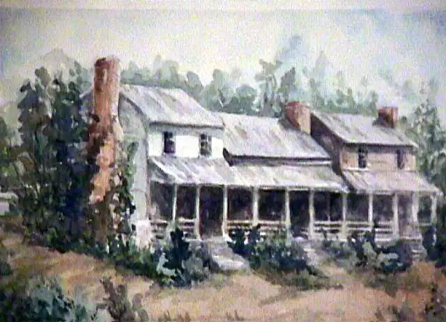
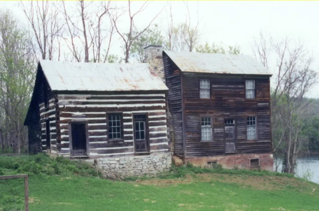
The Ingles House on the East Bank
Note that there are two Additions to the Original House on its Left
In 1782 William Ingles filed claim to 300 acres (LO G–230) located on the east bank of Wood’s River (New River) below (north) the mouth of the Middle River (Little River). This was based on an assignment made by Dr. Thomas Walker of the Loyal Company, which was later tied up in the estate of his son, and who failed to pay quit rent (real estate taxes). Ingles paid these taxes, and gained title to the land. Both the Zin and Walker lands are still in the Ingles family.
This ferry was one of several at Radford. If one were travelling toward the Narrows, one was likely to take Pepper’s Ferry located on the northern side of Radford. However, if one were taking the main Wilderness Road and its parallel route, the Island Road, which started at Fort Chiswell, on to the Holston Valley, one used the ford at Fort Frederick, later Ingles.
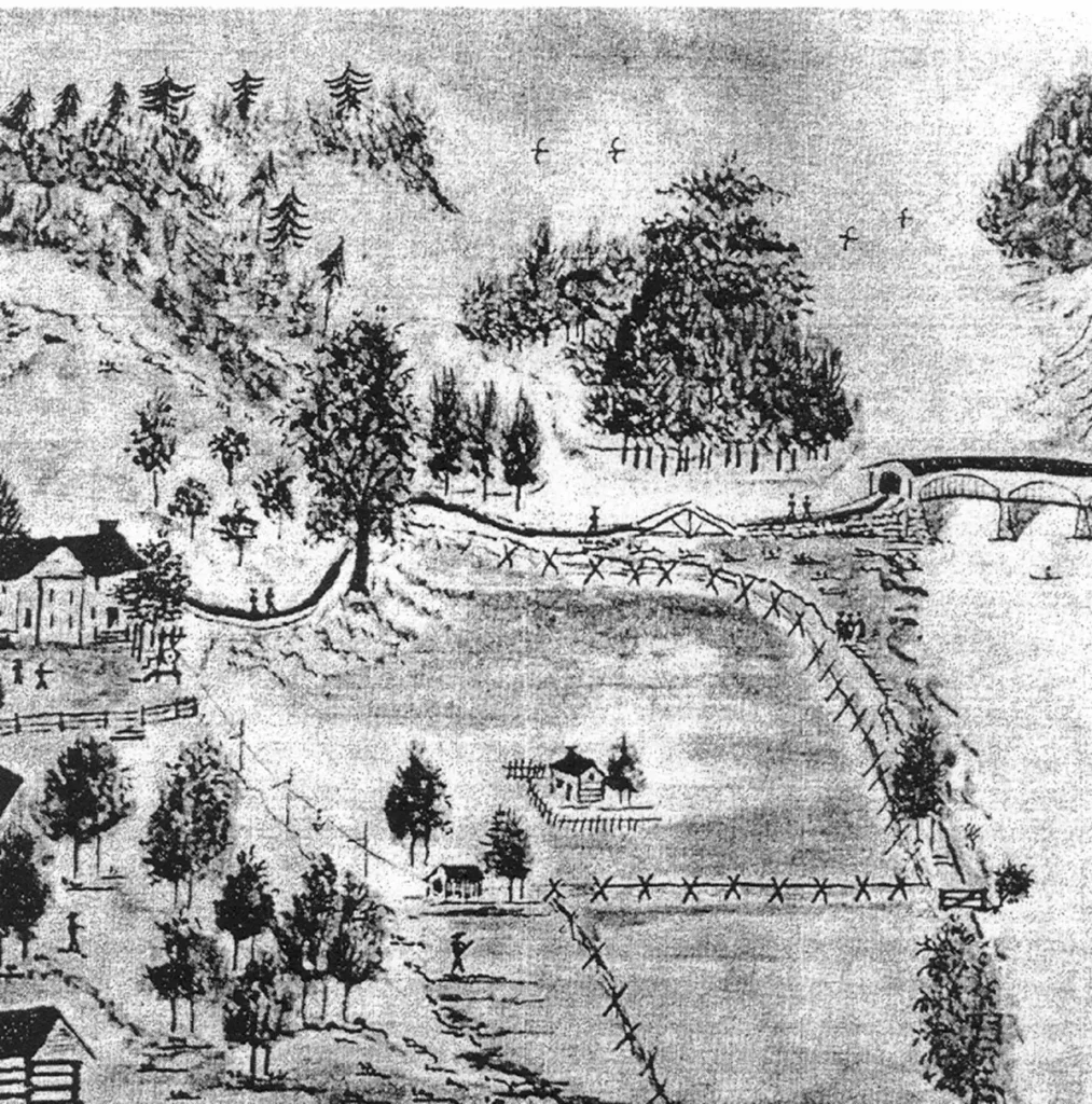
In 1842 the Ingles family built a large covered bridge between the ford and the ferry. A period drawing shows the bridge to have been of three arched spans supported by cut stone abutments on either bank, plus two pylons in mid stream. There was a ‘bridge house’, which functioned as a tollbooth, in the northern corner of the western abutment.
Lewis Miller’s Sketch of the Ingles Home and Covered Bridge looking Upstream (south)
Note that the Original House is Missing its later two Additions, which were Evidently Built After the Bridge was Built in 1842
The family built an inn on the western bank just opposite the ferry landing, and a couple of hundred yards down stream from the bridge, which was a couple of hundred yards down (north) from the ford.
Ingles Ferry Inn & Tavern
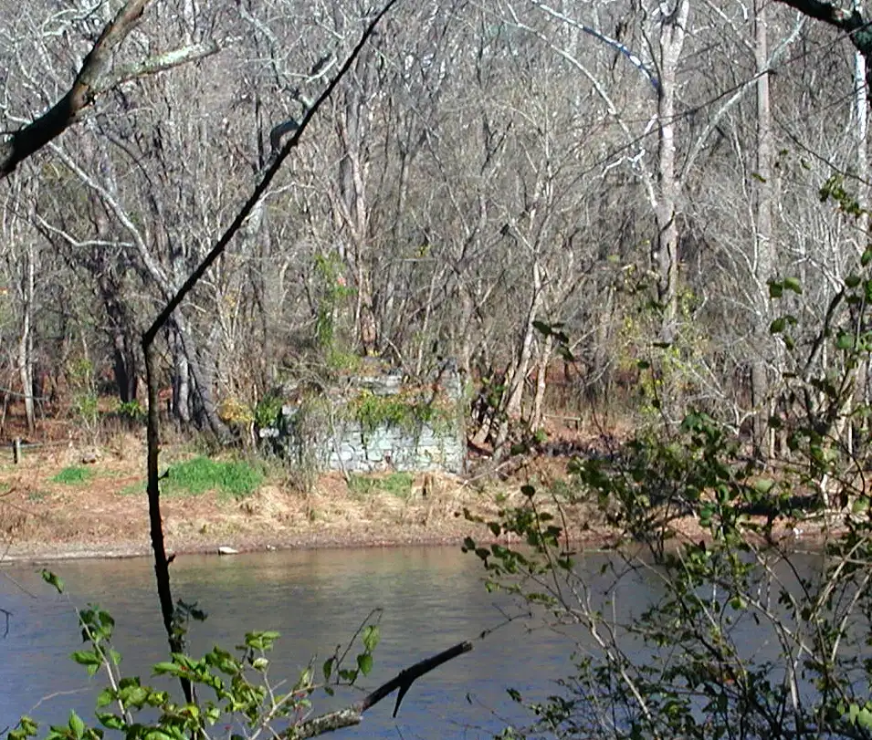
West Abutment and the Foundation Rubble of the Bridge House, or Toll Booth
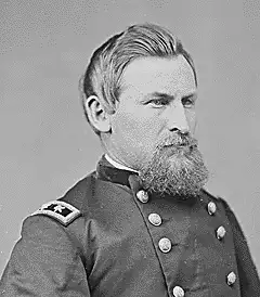
In May 1864 Union General George Crook burned both the railroad and turnpike (Ingles Ferry) bridges at Central Depot (Radford). This was part of Grant’s campaign to starve Lee out of his positions at Petersburg by denying him substance from Southwest Virginia and East Tennessee. He was opposed by Confederate General John McCausland, who commanded invalid units from Washington County, Virginia.
East Abutement
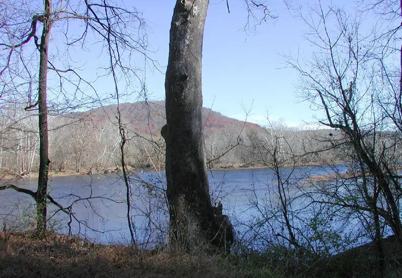
The Shoal and The Ford From The West Bank
The Wilderness Road crossed here and entered the Mouth of the Hollow just off the right Edge of the Photograph.
Union General George Crook, who Burned the Ingles Ferry Covered Bridge in 1864
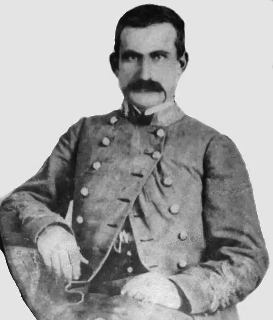
Confederate Brigadier General John McCausland, Whose Brigade of Invalids from Washington Co., Va. Opposed Crook
After the burning of the Ingles Bridge the ferry was reopened, and operated until 1948, when it sank with a truck on board. Today, both US 11 and I-81 have modern bridges across the New River at Radford.
This remarkable constellation of historic artifacts is viewable from a public road, State 611 (officially named ‘The Wilderness Road’, which in historic fact it is). To get there EXIT I-81 at the interchange just west of the Ingles Ferry Bridge over the New River at Radford. The distance is approximately two miles. This exit is labeled as access to Claytor Lake State Park, and as State 660. Turn north onto State Park Road (State #660) and proceed about a half mile to its intersection with the Wilderness Road (State # 611). Turn east onto the Wilderness Road and proceed to its dead end, which is about three miles. You will pass the Claytor Dam Road, which is the pioneer road to Dunkard’s Bottom. It is the author’s speculation that the most likely site for Fort Frederick is the two hundred yard stretch from this intersection to the collapsing log cabin on the south side of the Wilderness Road, right where the field turns into a deep hollow which contains the old Wilderness Road that approached the ford on the river. The beaten dirt of the old road still can be seen in the bottom of this gorge like hollow, and observed to disappear into the river at its edge.
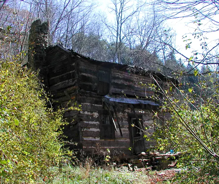
Log Cabin Made with V – joints – Located Beside the Wilderness Road on the West Approach to the River – Its Spring was Likely the Spring of Fort Frederick
Note two physical attributes of this hollow. It ends on the only shoal of rocks crossing the river all the way from the dam to well past the site of Ingles Ferry, there being deep pools of water both above and below this rock ledge. It is the only possible site for a ford. Secondly, note that the western river bank is too steep to allow horse or buffalo passage in all places except here at the head of this hollow, and at the ferry site downstream, where the water is too deep to allow fording. The State highway on both sides of the river is currently named ‘The Wilderness Road”.
Also note that the hollow is too deep to make it possible to have built a fort down in it until one comes to the head of the hollow at the collapsing log cabin. Note that the corner joints of this cabin are V – notched, and not half dove tailed. This dates the construction of the cabin to before 1820. The only spring on this stretch of road that runs between the head of the hollow and the intersection with the road to Dunkard’s Bottom is the spring that supplied this old cabin. It is the only possibility for the Spring of Fort Frederick, and is located as close to the ford as practical.