
Author: danielboonestg

  • Daniel Boone Wilderness Trail – Welcome

    Daniel Boone Wilderness Trail – Welcome

    The most daring effort to colonize the rich lands of the Kentucky River area were those of Colonel Richard Henderson, a Superior Court judge of North Carolina. Henderson decided that the best way to secure the area was to deal directly with the Cherokee Indians. He discussed his plans with friends and they formed the Transylvania Company and solicited the assistance of Boone in negotiating with the Indians and blazing the trail. Boone was no stranger to the Kentucky territory, having made several trips through the area. He wanted to make his home in Kentucky and was quick to accept Henderson’s offer.

    They found the Cherokee willing to sell the land between the Cumberland and Kentucky Rivers for 5 tons of serviceable goods. Final negotiations were held at Sycamore Shoals (now Elizabethton, TN), an ancient Cherokee treaty ground on the southern bank of the Watauga River, about 15 miles southeast of Long Island on the Holston, a sacred area to the Indians. After the agreement, Boone left for Long Island on the Holston to rendezvous with 30 armed and mounted axmen, among them his brother Squire, and son-in-law William Hays.

    On March 10, 1775, Boone led his trail blazers from Long Island to cut the trail through some 200 miles of wilderness northwest through the Cumberland Gap and into Kentucky.

    Boone was born in Pennsylvania in 1734. His family ventured into the Yadkin Valley of North Carolina in 1750 when Boone was 15. Four years later, he fought in the French and Indian War. A skilled woodsman, crack shot and tireless wayfarer, Boone later served two terms in the Virginia General Assembly, kept a tavern, led wars against the Shawnee Indians and continually moved around to escape what he called the “too crowded” conditions of 18th century Kentucky.

    This driving tour follows the Wilderness Trail to Cumberland Gap as closely as is possible. This guide is arranged by stops, beginning at the Long Island of the Holston near the historic Netherland Inn.
  • The Carter Cabin

    The Carter Cabin

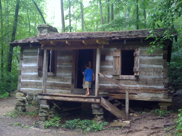
    The Carter Cabin is one of the oldest structures in Scott Co. Although we do not know the exact year it was built, we do know that according to family history, it was a part of the permanent settlement that grew up at the site of Crissman’s Fort, known also as Carter’s Fort, Rye Cove Fort, or Fort Lee. The original fort was built in 1774 by Isaac Crissman and turned into a permanent settlement ten years later by the brothers Thomas, Joseph, and Norris Carter. The cabin was later moved to the Carter Town area of Rye Cove where local historian Dr. Larry Fleenor tells us that it served as a stage relay station for the exchange of horse teams on the Fincastle Turnpike in the 1830s.


    As we look around the structure, please notice that no windows were placed along the back wall as a safeguard against Indian attack. At one time after it was moved to Carter Town, a porch and additional rooms were added and the exterior was weather-boarded, but the cabin as it stands today is the main room of the original structure. Legend has it that there was once a trapdoor in the floor where captured Indians were kept imprisoned and where Confederate ammunition was hidden during the Civil War.


    This structure has been passed down through six generations of Carters and was moved in 1997 to its present location at Natural Tunnel State Park through a generous donation to the Commonwealth of Virginia from the descendents of the Mosby J and Mary Ellen Boatwright Carter. The logs are original, but the mortar between the logs is not. The settlers would have used chink, a mixture of clay, water, straw, and manure. In addition, when the cabin was moved to the Park, protective renovations—including a new floor, roof, and front porch—were also completed in order to safeguard the original part of the structure.


    The Blockhouse Historical Area of the Park had not even been envisioned when the cabin was donated, which is why it was placed in its present location.